


#DindoPH: Typhoon enters PAR but will not make landfall
A typhoon known internationally as “Lionrock” just entered the Philippine Area of Responsibility (PAR) and is now known as typhoon “Dindo.”
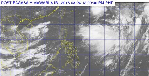
TYPHOON DINDO WAS LAST seen 1,200 East Northeast of Itbayat, Batanes. (Satellite image from Dost_pagasa Facebook page)
A severe weather bulletin issued by the Philippine Atmospheric, Geophysical and Astronomical Services Administration (PAGASA) at 1 p.m. today said that Dindo will have maximum sustained winds of 130 kph near its center and gustiness of up to 160 kph.
Dindo will not make landfall as it is expected to stay within the same area, roughly 1,200 km East Northeast of Itbayat, Batanes. It is expected to move South Southwest at a speed of 7 kph.
No tropical cyclone warning signals have been issued as of writing.
PAGASA advised the public and the disaster risk reduction and management councils concerned to take appropriate actions and watch for the next weather bulletin to be issued at 11 p.m. today.
Source: Dost_pagasa Facebook page, Rappler


